Road Trip
Solution
The first step is to identify the endpoints at the start and end of each shown trip, these are US states, with their stars positioned at the location of their capital city.
| Jackson, Mississippi | Columbia, South Carolina |
| Juneau, Alaska | Springfield, Illinois |
| Salem, Oregon | Saint Paul, Minnesota |
| Oklahoma City, Oklahoma | Denver, Colorado |
| Trenton, New Jersey | Salt Lake City, Utah |
The graphic at the bottom is attempting to clue the following:
- Using Google Maps, find the two capital cities.
- To measure the distance between the two:
- Right click on the starting city, and select "Measure distance"
- Left click on the ending city.
- The total distance will be shown at the bottom of the screen.
The flavor text hints at the module Crazy Maze, which contains cells for every two-letter combination. Finding the abbreviation for each US state, from either the USA Maze or USA Cycle manuals, it's noticed that the positions in each pair are close to each other in the maze.
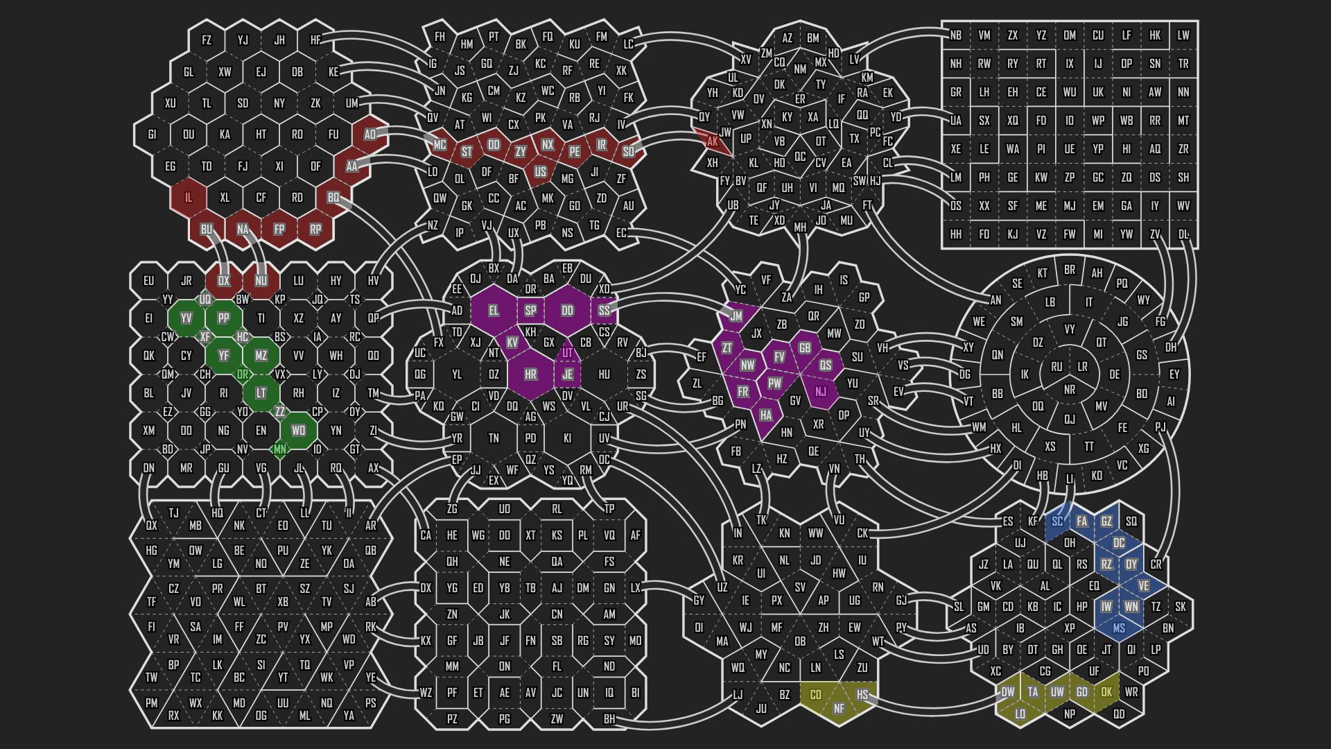
If you take a look at the number of steps it takes from the shortest path from one state's abbreviation to the other (shown above), and then take the distance shown (in miles, as would be used in the US) in between divided by the total distance gathered for each pair, it should be approximately equal to a rational number where the number of steps is the denominator.
| Distance Portion/Whole* | Step size Portion/Whole |
|---|---|
| 482.08/542.19 | ≈8/9 |
| 245.78/2335.15 | ≈2/19 |
| 132.36/1455.99 | ≈1/11 |
| 251.88/504.55 | ≈4/8 |
| 1139.35/1937.02 | ≈10/17 |
*For some reason, Google Maps' distances tend to fluctuate, but it shouldn't change the answer to the puzzle.
Going the indicated number of steps along each of the paths in the Crazy Maze manual reveals two-letter pairs to be extracted:
| 8th step from MS → SC | FA |
| 2nd step from AK → IL | IR |
| 1st step from OR → MN | YF |
| 4th step from OK → CO | LO |
| 10th step from NJ → UT | SS |
Finally, the clue at the bottom indicates that the answer you have at this point,
FAIRY FLOSS, should be changed to what it would be called in the US.
COTTON CANDY